


I arrived in Saint John, New Brunswick with a mental image worthy of a tourism poster: a tall waterfall in full reverse, a solid sheet of whitewater somehow flowing uphill as the legendary Bay of Fundy tides forced the Saint John River to run backwards. After all, the attraction is called “Reversing Falls.” What I actually found was a narrow urban gorge, brownish-green water and a phenomenon that felt less like a waterfall and more like a lesson in tidal physics that most visitors are never clearly taught.
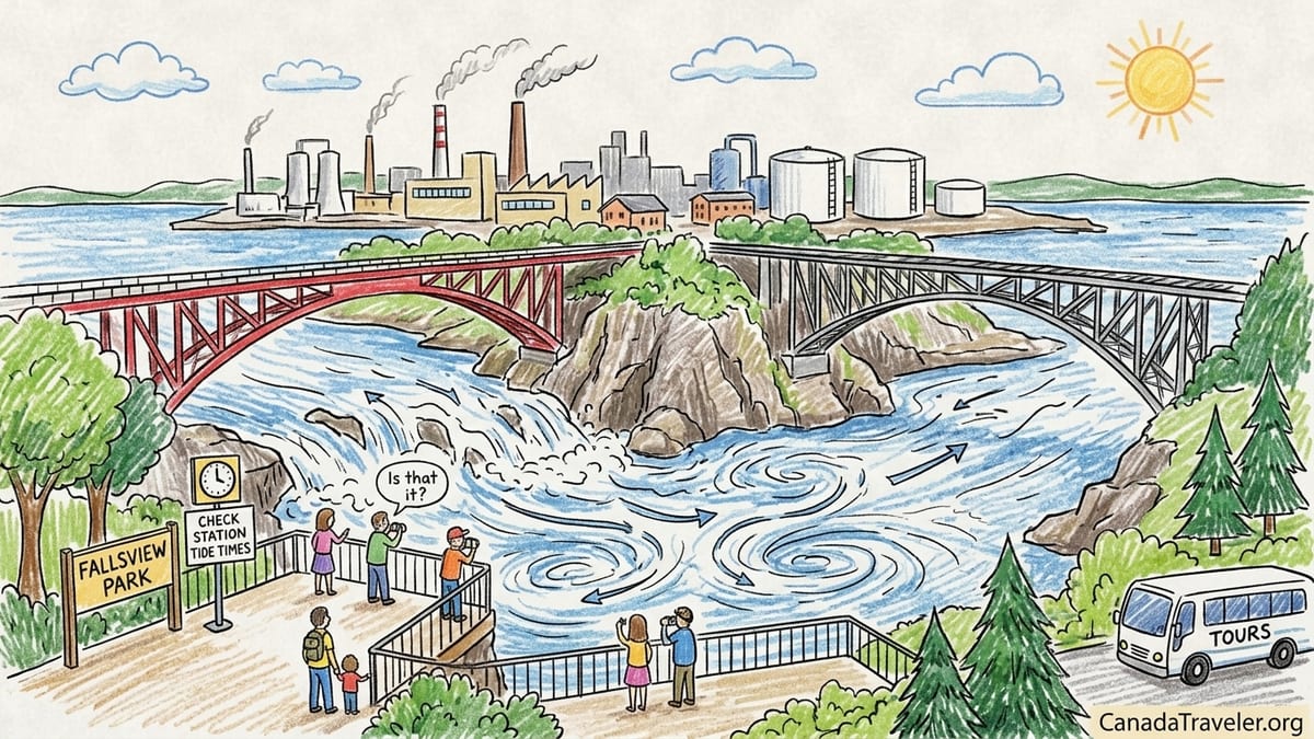
Expectation: A Niagara-Style Waterfall Running Backwards
The name “Reversing Falls” sounds almost cartoonishly dramatic. Before my trip, friends described it as a “waterfall that runs backward twice a day.” Cruise-ship brochures leaned into that story, pairing the name with stock images of vertical cataracts. It was easy to picture a cliff where the river pours over an edge, then suddenly stops and flows back uphill.
Driving into Saint John, that expectation felt reasonable. The city markets itself as the urban gateway to the Bay of Fundy, home to some of the highest tides on earth. It stands to reason that if anywhere could host a reversing waterfall, it would be here. I built my day around seeing that reversal, planning a quick stop between coffee in the historic uptown and an afternoon along the waterfront.
By the time I followed Route 100 toward the Reversing Falls Bridge, my phone’s map pin sat confidently on what it called “Reversing Falls Rapids.” The extra word should have been a hint. I was still braced for a plume of water exploding out of a narrow canyon or crashing over visible ledges. Instead, I rolled across a two-lane span flanked by industrial yards and pipelines, wondering if I had somehow missed the main event.
Only when I parked at Fallsview Park and walked to the railings did the truth come into focus: there is no conventional waterfall here at all. There is a gorge, there are rapids, and under the right conditions there is powerful, chaotic water. But nothing resembles the vertical “falls” that the name suggests.
Reality: A Working Gorge in an Industrial City
Standing at Fallsview Park, the first surprise is how urban the setting feels. The Saint John River squeezes through a rocky gorge under two separate bridges: the road-carrying Reversing Falls Bridge and the steel truss Reversing Falls Railway Bridge just upstream. Across the water rise tanks, chimneys and industrial buildings. Instead of forested cliffs and misty spray, you look at rock faces that have needed stabilization work and the infrastructure of a working port city.
The gorge itself is impressive in a quieter way. Sheer rock walls drop to the constricted channel where the river meets the outer reach of the Bay of Fundy. On my visit, the water was a turbid brown-green, carrying the silt you would expect from a major river. It smelled less like pristine wilderness and more like a hard-working estuary on the edge of heavy industry.
Traffic roared behind me on Fallsview Drive and the bridge. Tour buses squeezed into a small parking area, then wrestled their way back into city traffic. A few visitors stepped out, took a handful of photos, and were gone less than ten minutes later. Several of them asked each other the same question I had in my head: “Is that it?”
What I was watching at that moment was a tidal river mid-cycle: moving, but not wildly. Without understanding what you are supposed to see, the gorge can look like little more than a bend in a troubled urban river. There are days and times when it erupts into something more dramatic, but catching that show is the heart of the problem.
Why There Is No Vertical “Fall” to Reverse
The key misconception is embedded right in the name. At Saint John, there is no drop like Niagara, no clean edge where a river tips into empty air. Instead, the Saint John River, also known by its original Wolastoq name, reaches the sea through a narrow rock gorge. On the seaward side lies the outer harbor and, beyond that, the Bay of Fundy, whose semi-diurnal tides rise and fall roughly twice each day.
When the ocean is low, the river flows outward through the gorge as you would expect, often with energetic rapids and standing waves as water funnels through the constriction. As the tide in the bay rises, however, it sends a rising wall of salt water pushing back against the river. Eventually the tide climbs high enough to match the river’s level on the inland side of the gorge. For a short period, the two bodies of water nearly balance and the current slows to a relative standstill. Then the sea level passes the river’s level and the tide begins to win, forcing water to run landward through the same gorge. The “reversal” is really a shift in current direction driven by the ocean’s rise and fall, not a waterfall suddenly climbing uphill.
Canadian sailing directions and local tide guides describe this in the bluntest possible terms: Reversing Falls is a series of rapids created by the difference in water level on each side of the gorge, and the so-called slack water between outward and inward runs lasts on the order of minutes, not hours. What people imagine as a switch being thrown is, in truth, a gradual trade in dominance between river and sea. The water does not flip direction in front of your eyes in a few cinematic seconds. That would violate basic physics.
From a safe overlook, this matters because the spectacle depends on the size of the tidal range, the volume of river flow, recent rainfall and even wind direction. On a day with moderate tides or low river discharge, the change in appearance between outward and inward runs can be surprisingly subtle. The differences show in patterns of boils, whirlpools and seams, not in cliffs of whitewater. Visitors primed for a waterfall will understandably feel underwhelmed.
The Timing Trap: Why Most Visitors Miss the Best Moments
The other misunderstanding is about timing. In conversation, locals will say the tide “turns” a couple of times a day. That sounds like something scheduled, a quick event you can slot in before lunch. In reality, the entire tidal cycle in the Bay of Fundy runs about 12 hours and 25 minutes from high tide to the next high tide. Outgoing and incoming flows through the gorge each last for hours.
The only truly special moments are the slack intervals when the outward current subsides before inward flow starts, and vice versa. Canadian Hydrographic Service notes that slack periods at Reversing Falls tend to last around ten minutes. Crucially, they occur at specific offsets from high and low water in the harbor, not right at those times. This means you cannot simply look up “high tide Saint John” on a generic tide app and expect that to match the moment of reversal in the gorge.
Hydrographic authorities deal with this by giving the Reversing Falls its own virtual station, number 00066, in their official water-level tools. Instead of just listing the times of high and low tide, the Reversing Falls station shows predictions labeled “End of inward run” and “End of outward run.” Those are the practical slack-water times, when the current is about to change direction and the turbulent patterns are at their most transitionary.
To see how this plays out, look at a specific example. For Wednesday, October 28, 2026, the Canadian Hydrographic Service’s Reversing Falls station 00066 lists 11:28 a.m. Atlantic Daylight Time as the “End of outward run” and 4:10 p.m. ADT as the “End of inward run.” In plain language, around late morning the last of the seaward-flowing river current is expected to give way to the flood tide, and by mid-afternoon the landward surge should ease before the river asserts itself again.
It sounds precise, even scientific, and it is. But this is where expectations collide with reality. Those times do not guarantee towering whitewater or dramatic standing waves at the exact minute shown. At 11:28 a.m., the water may actually look its calmest, since slack by definition is the moment of least motion. If you walk up to the railing with the romantic idea that “11:28 is when the falls reverse,” you are likely to stare at deceptively placid water and wonder what you did wrong.
Why Generic Tide Tables and Tour Schedules Are Not Enough
Many visitors never hear about station 00066 at all. Instead, they search for “Saint John tide times” and end up with harbor predictions that list straightforward high and low water. Those numbers are not useless, but they are not aimed at explaining the current in the gorge. The slack periods at Reversing Falls occur hours after the reported harbor highs and lows, because it takes time for the pressure difference to build and the flow to respond in the constricted channel.
As a result, you see a common pattern. Cruise passengers dock at the uptown terminal, hear that “Reversing Falls are best about high tide,” hop in a cab, and arrive to water that appears to be doing very little. Meanwhile, a kayaker or jet-boat operator, working from Canadian Hydrographic Service tools and detailed local guidance, times their runs to match the most powerful outgoing or incoming currents. Both groups were in the same city on the same day. Only one saw the place at its best.
On my own visit, I deliberately used the Reversing Falls station rather than an unrelated harbor table. I pulled up the official Canadian water-level application, searched for station 00066, made sure the time zone was set to Canada/Atlantic, and noted the slack times. I arrived at Fallsview Park well before the late-morning “End of outward run,” intending to watch the tail end of the outgoing rapids mellow into stillness, then slowly reverse.
Instead of a sharp reversal, the change crept up on me. Twenty minutes before the predicted slack, the current still showed clear seaward flow, with streaks of foam sliding past the rock ledges. Ten minutes before, small boils near mid-channel softened. At the actual predicted time, the surface smoothed out. Only fifteen or twenty minutes later did subtle curls on the surface start to point inland. If I had been limited to a quick cruise-ship bus stop, there is a good chance I would have missed most of the drama entirely.
Fallsview Park vs Wolastoq Park: Two Very Different Vantage Points
The viewing experience also depends heavily on which side of the gorge you choose. Most first-time visitors are delivered to Fallsview Park, on the western side off Douglas Avenue and Fallsview Drive. It offers multiple lookouts, railings right along the cliff edge and a more or less face-on view of the channel. From here you can watch both the railway bridge and the road bridge framed against the churning water, which makes it the default stop for tour buses and taxis.
Fallsview’s strengths are its proximity to the water and its quick in-and-out access from the main road network. If you have only ten minutes to spare or you are traveling with someone who has limited mobility, the short walk from parking lot to railing is an undeniable advantage. The trade-off is atmosphere. You can hardly escape the hum of engines, the sight of industrial facilities across the river, and the claustrophobic arrangement of cars and buses jostling for spaces. It feels like a roadside pullout that happens to overlook a famous phenomenon, not an immersive natural setting.
Wolastoq Park, perched on the opposite bank above the railway bridge, offers a very different mood. The park sits in a residential neighborhood and includes sculptures and green space as well as its overlook. To reach it, you navigate local streets rather than main arteries, and the short climb from the roadside involves some stairs and paths that will be challenging for those with mobility issues but manageable for most walkers. The reward is a more expansive perspective looking back toward the gorge and out over the lower river.
From Wolastoq Park, the industrial clutter recedes slightly in the frame. The bridges stack at angles, and the texture of the water is easier to read across a larger slice of the channel. If you want to watch the overall pattern of the tide’s influence rather than stare at a single standing wave, this is the more revealing viewpoint. For photography, especially around golden hour, Wolastoq’s higher vantage point can soften some of the site’s urban harshness, though smokestacks and tanks never disappear completely.
The Problem of Short Visits and Underwhelming Conditions
What makes Reversing Falls so vulnerable to visitor disappointment is the collision between its complex timing and modern travel habits. Many people encounter it as a brief stop on a larger itinerary: a 10-minute bus detour on the way back to a cruise ship, a quick side trip while driving between Fundy National Park and the Nova Scotia border, or a spontaneous pull-in after seeing the word “Falls” on a highway sign.
If you scoop ten random visitors into that pattern, the odds are high that several will arrive at completely unremarkable moments in the tidal cycle. Midway through an outgoing or incoming run, the river looks busy but not extraordinary. Around slack, it can look positively dull. Because the gorge is hemmed in by industry, there are no hiking trails that let you wander along a wild river while you wait for conditions to improve. You stand at a railing, take a few pictures, and either get lucky or you do not.
The name itself makes this worse. If the site were promoted primarily as “Reversing Rapids” or “Fundy Tidal Gorge,” people might adjust their expectations downward and still be pleasantly surprised by any visible turbulence. Instead, the word “Falls” primes visitors for a sensory experience on the scale of Montmorency Falls near Quebec City or even a smaller version of Niagara. When they find a horizontal river whose drama is hidden in its currents, they feel misled.
Add the urban-industrial backdrop and the sensory palette is more workmanlike than romantic. On some days you may notice industrial smells. On others, mist or drizzle flatten the colors and make the brown water look even more opaque. There is no soundtrack of crashing water, because much of the energy goes into subsurface hydraulics rather than airborne spray. To appreciate what is happening, you need patience, a willingness to watch the same rock eddy for several minutes, and at least a basic grasp of tides.
Stonehammer Geopark: Geological Importance vs Tourist Experience
There is a deeper story beneath the surface that rarely reaches hurried visitors. The Reversing Falls gorge forms one of the flagship sites in the Stonehammer UNESCO Global Geopark, which sprawls across the Saint John region. The rocks at the gorge record a collision of ancient continents, a junction between terranes that once lay oceans apart. Stand here with a geologist and you are metaphorically standing astride pieces of Earth that traveled thousands of kilometers before welding together.
Stonehammer’s status is often misunderstood. A UNESCO Global Geopark is not the same thing as a UNESCO World Heritage Site. World Heritage status recognizes cultural or natural properties of “outstanding universal value” and tends to focus on preserving a specific location. A Global Geopark, by contrast, is a broader region where geological heritage is managed holistically alongside sustainable tourism and community development. It is more about storytelling and education across a landscape than about a single spectacular viewpoint.
At Reversing Falls, that means the real value lies in how the gorge illustrates tectonic history and ongoing tidal processes, not in providing a postcard-perfect waterfall. Educational signage, guided geology walks and Stonehammer interpretive materials can unlock that side of the experience for those who seek it out. Unfortunately, most short-stay travelers never scratch that layer. They see the word “UNESCO” associated with Stonehammer and assume the lookout itself will rival icons like the Grand Canyon or Iguazu Falls. When it does not, they fault the attraction rather than their own inflated expectations.
If you are the kind of traveler who loves reading rock faces, tracing fault lines with your eyes and imagining vanished oceans, Reversing Falls becomes much richer. You start spotting boundaries in the cliff walls, noticing rock types, and reading the gorge as a cross-section through deep time. But nothing about the bus parking lot or souvenir stands signals that this is what you should be doing. The geopark story remains an optional, easily missed layer.
The Takeaway
After a full day of timing, watching and returning for a second phase of the tide, I left Saint John with mixed feelings about Reversing Falls. As a piece of physical geography, it is quietly fascinating. The idea that a river’s current can reverse direction twice a day because of the sheer height of the Bay of Fundy tides deserves contemplation. The geology that locks those waters into a narrow gorge merits its place in a UNESCO Global Geopark.
As a mainstream tourist attraction, however, it is easy to see why locals sometimes roll their eyes. The name “Reversing Falls” plants a mental image that the site cannot deliver, especially not in a rushed 10-minute stop between tour buses. The industrial setting, the dependence on precise tidal timing and the subtlety of the phenomenon work against instant gratification. On a random schedule, you are as likely to encounter lethargic murk as lively rapids.
If you are on a tight itinerary or already passing across the Reversing Falls Bridge, the site justifies a free 10 to 20 minute pause. Park at Fallsview for convenience, peer down into the gorge, cross to Wolastoq Park if you have the time and energy, and treat the stop as a window into how powerful Fundy’s tides really are. Do not detour hundreds of kilometers solely to see this spot unless you are genuinely interested in tides and geology.
Where Reversing Falls becomes genuinely meaningful is when you intentionally see it at two different tidal phases. Use the Canadian Hydrographic Service’s station 00066 to find a pair of “End of run” times that fit your day, then visit once during the strong outward or inward current and again closer to slack. Watch how the same rocks, bridges and industrial skyline are transformed by changes in the water’s movement. Instead of chasing a mythical backward waterfall, you will be witnessing a more subtle, honest story: a daily negotiation between river and sea that does not care in the slightest what name the tourism brochures chose to print.
FAQ
Q1. Is there an actual waterfall at Saint John’s Reversing Falls?
There is no vertical waterfall here. Reversing Falls is a series of rapids in a narrow gorge where the Saint John River meets the Bay of Fundy, and the apparent “reversal” is the river current changing direction with the tide.
Q2. How should I time my visit to see the water reverse direction?
Use the Canadian Hydrographic Service’s Reversing Falls station 00066, which lists “End of inward run” and “End of outward run” times. These mark approximate slack water when the current is about to switch direction, but the visual change is gradual, not instant.
Q3. Why can tide tables for the harbor be misleading for Reversing Falls?
Standard Saint John harbor tide tables show high and low water levels, not the current in the gorge. Slack at Reversing Falls occurs hours after those highs and lows, so relying only on harbor times can leave you standing there when little appears to be happening.
Q4. How long does a full tidal cycle take at Reversing Falls?
The Bay of Fundy’s tides complete a cycle in about 12 hours and 25 minutes. Outward and inward runs through the gorge each last several hours, while the slack periods between them are on the order of ten minutes.
Q5. On October 28, 2026, when are the key times to watch?
On Wednesday, October 28, 2026, Reversing Falls station 00066 predicts the end of the outward run at about 11:28 a.m. ADT and the end of the inward run at about 4:10 p.m. These are useful reference points, but weather, river flow and other factors can make the visual effects stronger before or after those minutes.
Q6. Which viewpoint is better, Fallsview Park or Wolastoq Park?
Fallsview Park is easier to reach, close to the water and convenient for quick stops, but it feels very urban and busy. Wolastoq Park requires a short climb and local-street navigation, yet offers a calmer atmosphere and a broader perspective on the gorge and bridges.
Q7. Is Reversing Falls worth a special trip if I am short on time?
If you are already in Saint John, it deserves a free 10 to 20 minute stop. As a stand-alone destination, it is best suited to travelers who care about tides and geology and are willing to plan around the timing, rather than those seeking a classic postcard waterfall.
Q8. How does Stonehammer UNESCO Global Geopark relate to Reversing Falls?
Reversing Falls is one of the key sites within Stonehammer UNESCO Global Geopark, a regional designation that highlights important geology and promotes education and sustainable tourism. It is different from a UNESCO World Heritage Site, which focuses on individual properties of exceptional universal value.
Q9. Can I expect dramatic whitewater every time I visit?
No. The intensity of the rapids depends on the size of the tide, river flow and weather. On some visits, the water may look relatively calm, especially near slack. On others, you may see strong standing waves and whirlpools. There is no guarantee of spectacle on a random short stop.
Q10. How much time should I plan if I want to understand the phenomenon properly?
Ideally, set aside a few hours in your day so you can visit twice at different tidal phases, for example once during a strong outward or inward run and again closer to slack. Watching the gorge change over time makes the “reversing” effect far clearer and more rewarding.