


Trying to “do” all five Great Lakes in one Canadian road trip usually leads to long, forgettable highway days and rushed stops in the places that deserve time. A smarter approach is to think in distinct lake-focused routes and then link one or two together. The Canadian shores of Lake Huron, Lake Superior, Lake Erie and Lake Ontario all offer very different styles of driving, scenery and roadside culture, from wind-swept cliffs and Group of Seven vistas to sandy beaches, vineyards and historic parkways.
How to think about Canadian Great Lakes road trips
The Canadian side of the Great Lakes sprawls from the U.S. border in southwestern Ontario to the North Shore of Lake Superior near the Manitoba line. Distances look manageable on a map but can be deceiving on the ground. The drive from Sault Ste. Marie to Thunder Bay along Lake Superior’s north shore alone is roughly 700 kilometres, often with single-lane highway and long gaps between services. That is a full day’s drive, and most travelers stretch it over two or three days to enjoy the scenery.
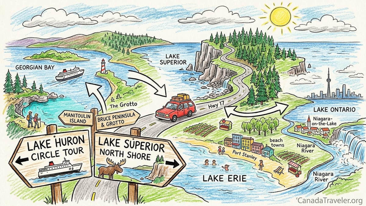
For planning purposes, it helps to treat each lake, or a major section of it, as its own road trip. This guide focuses on four realistic routes: a Lake Huron and Georgian Bay circuit anchored by Manitoulin Island and the Bruce Peninsula, the Lake Superior north-shore drive, a Lake Erie wine-and-beach route from Windsor toward Niagara, and a Lake Ontario and Niagara route centring on Toronto and the Niagara Parkway. Each can fill a long weekend to a week on its own without ever feeling rushed.
These routes can be linked, but not all in a single loop without a lot of backtracking and highway slog. Many visitors fly into Toronto, pick up a rental car and then either loop Huron and Georgian Bay before connecting to Superior, or head south and east to combine Lake Erie’s wineries with Lake Ontario’s cities and the Niagara region. Carefully consider your available time: as a rough rule, allow at least five days for a relaxed version of any one of these routes, seven to ten days if you plan to connect two.
The Great Lakes region is also heavily seasonal. July and August bring warm water and busy beaches but higher prices and more crowded campgrounds. May, June, September and early October often provide the best balance of open services, comfortable driving temperatures and fewer crowds. On Lake Superior and the more northerly stretches of Lake Huron, early and late season can still mean chilly evenings and the possibility of fog or sudden weather changes, so pack layers and plan driving days that leave daylight for the most scenic sections.
Lake Huron & Georgian Bay circuit: Manitoulin and the Bruce Peninsula
A classic Canadian Great Lakes road trip on Lake Huron focuses on Manitoulin Island, the Bruce Peninsula and the North Channel coast. Many travelers start this roughly 800 to 1,000 kilometre circuit in Toronto, driving north via Highway 400 and 69 to Sudbury, then west toward Espanola and south to Manitoulin Island. From there, the Chi-Cheemaun ferry carries vehicles between South Baymouth on Manitoulin and Tobermory at the tip of the Bruce Peninsula, usually operating from early May to mid or late October. Taking the ferry avoids a long drive back through Sudbury and turns the lake into part of the adventure.
Manitoulin Island itself rewards at least two nights. It is the world’s largest freshwater island, with small communities like Little Current, Manitowaning and Gore Bay, First Nations cultural centres, and easy hikes to viewpoints over the North Channel. Budget at least a day to explore the island’s backroads, swim at quiet public beaches and try local fish and chips, often whitefish or pickerel landed from Lake Huron. Accommodation ranges from simple motels and lakeside cabins to campgrounds and a handful of inns, so booking ahead in July and August is essential.
On the Bruce Peninsula side, Tobermory is the postcard village of the route. Brightly painted harbourside buildings, glass-bottom boat tours of shipwrecks in Fathom Five National Marine Park and popular trails and turquoise coves in Bruce Peninsula National Park make it one of Ontario’s most in-demand summer destinations. A typical traveler might spend two or three nights here, combining a day on the water with a hike to the Grotto and sunset at one of the rocky shorelines. Continuing south, the Bruce Peninsula towns of Lion’s Head, Wiarton and Sauble Beach add quieter bays, sandy beaches and more affordable accommodation.
This Huron and Georgian Bay circuit can be driven in four or five days, but seven is more realistic if you want to linger. It also connects naturally with the Lake Superior route. From Tobermory, you can drive south to Owen Sound, then cut northeast toward Sudbury and Sault Ste. Marie, effectively linking the Huron circuit with Superior’s North Shore drive. Travelers with ten to fourteen days can comfortably do both, turning Lake Huron and Lake Superior into a single, memorable Canadian road trip focused on wild shorelines and small northern communities.
Lake Superior’s north shore: Canada’s wild coastal highway
The north shore of Lake Superior in Ontario is one of the country’s most legendary drives. The core section runs on Highway 17 between Sault Ste. Marie and Thunder Bay, roughly 700 kilometres of mostly two-lane Trans-Canada Highway skirting dense forest, cliffs and long stretches of freshwater horizon. There are no true cities between the two, only small towns like Wawa, Marathon and Nipigon, and the scenery between them is a highlight in itself: granite headlands, cobble beaches, waterfalls and sweeping views across the lake that often feels like an inland sea.
Most travelers approach from the east, either driving up from southern Ontario to Sault Ste. Marie or linking from the Lake Huron circuit via Sudbury. It is technically possible to drive from Sault Ste. Marie to Thunder Bay in a long day, but a safer and more enjoyable plan is to spend two or three days on this stretch. A common pattern is to overnight near Lake Superior Provincial Park, then again around Marathon or Terrace Bay. This breaks the driving into segments of three to four hours, leaves time for short hikes to viewpoints such as Old Woman Bay, and allows for slowdowns due to road construction or wildlife on the road.
Services on this route can be widely spaced, especially outside July and August, when some seasonal motels and restaurants close. Always start the day with a full tank of fuel and carry snacks and water. Expect to pay slightly higher prices for fuel and groceries compared with southern Ontario, reflecting the remote logistics. Accommodations are a mix of roadside motels, provincial park campgrounds and a scattering of lodges and cabins that book up well in advance in peak season, particularly near popular parks and beaches.
Weather on Superior can change quickly. Fog and rain can roll in even on summer days, and the lake moderates temperatures, which means cooler evenings than you might expect at this latitude. For renters, confirm that your vehicle includes a proper spare tire and jack, and check with your rental company about driving on gravel access roads to remote beaches or trailheads. Some agencies forbid unpaved roads, and in any case, it is wise to avoid rough tracks when you are hours from a major service centre. If you have more time, extending west from Thunder Bay toward the Manitoba border or across into the U.S. section of the Lake Superior Circle Tour turns this into part of a multi-country Great Lakes circuit.
Lake Erie’s north shore: wine country and warm-water beaches
Lake Erie’s Canadian shore feels very different from Huron or Superior. Here the focus is on low-key beach towns, some of Ontario’s warmest lake swimming and long-established wine regions. A typical route starts near Windsor or the Detroit border, then follows the north shore east through towns like Kingsville and Leamington, skirts Point Pelee National Park, and continues through Port Stanley, Long Point and Port Dover toward the Niagara Peninsula. The driving distances between stops are modest, often an hour or less, which makes this route ideal for travelers who prefer more time out of the car.
Southwestern Ontario’s climate is among the warmest in Canada, and Lake Erie’s shallower waters heat up quickly. By July and August, beaches near Port Stanley, Turkey Point and Long Point often see water temperatures that feel comfortable even for tentative swimmers. Many travelers base themselves in one or two communities for three or four nights and make day trips to others, rather than changing accommodation every night. In practice, it is easy to spend a lazy afternoon at Port Stanley’s main beach, then drive to a lakeside motel or cottage rental in time for sunset.
This shore is also prime wine country. Essex County around Kingsville and Harrow has a growing cluster of wineries that often pair tastings with casual patios and vineyard views, while the Niagara region nearer the east end of Erie is one of Canada’s most established wine destinations. It is straightforward to arrange a local winery tour by shuttle or small group minibus in both areas, which is strongly recommended if you plan to sample more than a small tasting flight. For self-drivers, many wineries waive a tasting fee with the purchase of a bottle, and it is easy to spend a full day visiting three or four within short driving distance.
A Lake Erie road trip can stand on its own as a five- to seven-day holiday from Toronto or Detroit, or it can connect with the Lake Ontario and Niagara route. It is also one of the more rental-car-friendly options, with frequent fuel, food and accommodation choices and relatively short driving days. Travelers who want beach time, wineries, small-town main streets and family-friendly attractions like farm stands and ice cream shops will find Erie a good match. Those seeking wild, empty shorelines and long day hikes may be happier focusing on Huron, Georgian Bay or Superior.
Lake Ontario & Niagara: cities, culture and the classic parkway
Lake Ontario’s Canadian shore is far more urban than the others in this guide, but it still offers satisfying drives, especially when combined with the Niagara region. Most international travelers arrive via Toronto, pick up a rental car at the airport or downtown and then have a choice: spend a few days exploring the city before heading out, or immediately set off east or south along the lake. The direct drive from Toronto to Niagara Falls via the main highway is about 130 kilometres and can take under two hours in light traffic, but taking the slower lakeside roads and the Niagara Parkway transforms it into an all-day scenic outing.
The Niagara Parkway runs along the Canadian side of the Niagara River between Niagara-on-the-Lake and Fort Erie, passing orchards, wineries, river viewpoints and the falls area itself. It has been called one of the prettiest Sunday drives in the world and is at its most atmospheric during late September and early October, when vineyards turn gold and red and roadside farm stands pile up with apples and pumpkins. Many visitors base themselves in Niagara-on-the-Lake, a small historic town known for its 19th-century architecture and theatre festival, and then drive or join organized tours along the parkway and to the falls.
Further east along Lake Ontario, the shoreline between Hamilton and Kingston mixes cities, industrial port areas, small towns and rural stretches. The region has its own wine trail and a signed waterfront route used heavily by cyclists, which road trippers can loosely follow on secondary roads to stay close to the lake. Sample itineraries might include a night in Prince Edward County, known for its wineries and sandy provincial park beaches, or a stop in Kingston to explore its limestone downtown and history as a former capital. Driving this section between Toronto and Kingston directly on the main highway takes under three hours, but allowing a full day or more gives time to explore the smaller waterfront communities and viewpoints.
Travelers can comfortably combine Lake Ontario and Niagara with the Lake Erie route in a week-long trip, using Niagara as the natural pivot between the two lakes. It is generally easiest to rent and return a vehicle in Toronto for these southern Ontario loops, as the city has the widest choice of rental companies, one-way options and vehicle categories. Those planning to continue north toward Georgian Bay or Huron should allow extra time to cross the Greater Toronto Area, where traffic congestion can easily add an hour or more to expected driving times.
Linking routes, ferries and realistic driving distances
While it is tempting to look at a map and draw a giant loop around all four lakes, the road realities argue for a more modest plan. Linking Lake Ontario and Lake Erie is simple. You can drive a rough semicircle from Windsor to Niagara and up to Toronto in about a week, with daily legs of 150 to 250 kilometres, giving plenty of time for beach stops and wine tastings. Alternatively, make Toronto your base and do a shorter four- or five-day loop that uses the city as both start and finish, visiting Port Stanley and the north shore of Erie on the way out and the Niagara Parkway on the way back.
Connecting Lake Huron and Lake Superior requires longer distances but pays off in scenery. A common approach is to start in Toronto, drive north through Sudbury to Manitoulin Island, take the Chi-Cheemaun ferry to Tobermory, then loop back through Owen Sound and north again to Sault Ste. Marie and along Superior to Thunder Bay. This kind of trip requires at least ten days to feel relaxed, with several legs in the 300 to 500 kilometre range. Chi-Cheemaun ferry crossings take under two hours, but you must arrive at the terminal well before departure and reservations are strongly recommended in summer and on holiday weekends.
Travelers determined to connect southern Ontario’s wine-and-beach country with the wild north shore of Superior often plan a one-way itinerary. For example, you might spend several days along Lake Erie and the Niagara region, then drive north through Toronto, Sudbury and Sault Ste. Marie to do the Superior drive to Thunder Bay, and fly home from there after dropping the car. This avoids retracing your route but does require a rental company that supports one-way rentals between major Ontario cities, sometimes with a surcharge. When searching, look for “one-way drop fee” details in the booking conditions and compare prices between agencies.
Ferries are limited but helpful. Beyond the Chi-Cheemaun, seasonal local ferries connect smaller Lake Huron and Georgian Bay islands and peninsulas, but they mostly serve residents and short-hop visitors rather than through-drivers. None provide a practical shortcut between Erie, Ontario and Superior routes. Factor in that ferry timetables can change year to year, and sailings can be affected by weather. Always treat the current season’s schedule as your authority and build in time on either side of sailings in case of delays.
Rental-car considerations and choosing the right route
Most overseas visitors pick up a rental car in Toronto, Ottawa or occasionally Winnipeg for these Great Lakes routes. In southern Ontario around Lakes Erie and Ontario, nearly any standard rental car is fine: compact or midsize sedans, small crossovers and minivans all cope easily with the good paved roads and frequent services. For Lake Superior and the more remote sections of Huron, it is worth paying attention to a few extra details. Ask for a vehicle with modern safety systems and a full-size spare if possible, and confirm your rental includes unlimited kilometres if you are planning a long loop that could easily exceed 2,000 kilometres.
Most rental contracts in Ontario specify that vehicles must be driven on paved roads. While there are many enticing gravel turnoffs toward secluded beaches and trailheads, staying on maintained public roads minimizes the risk of damage and issues with roadside assistance. In more remote areas like Lake Superior’s north shore, cell coverage can be intermittent, so note down emergency numbers and the approximate kilometre markers of your day’s route before setting off. Carry a physical map or have offline maps downloaded, especially if you rely on navigation apps that assume constant data coverage.
Choosing which route to drive ultimately comes down to your interests and how you like to travel. If your ideal holiday features long hikes, big views, campfires and the feeling of being far from cities, then Lake Superior and the wilder stretches of Huron and Georgian Bay will appeal most. If you prefer short drives, small towns, farm stands, wine tastings and evenings in walkable historic centres, Lake Erie and the Lake Ontario and Niagara route will likely be a better fit. Families with younger children often gravitate to Erie’s beaches and southern Ontario’s mix of attractions, while repeat visitors to Canada increasingly seek out Superior for its sense of space and drama.
Time of year matters as much as route choice. Late spring and early autumn are ideal for road trippers who want fewer crowds and do not mind cooler water temperatures. July and August are perfect for swimming and beach time but require more advance planning for ferries, campgrounds and popular inns, particularly in places like Tobermory, Niagara-on-the-Lake and the most accessible sections of Lake Superior’s coast. Winter driving on these routes is a separate undertaking entirely, with snow and ice common across much of Ontario from November into March, and most casual visitors are better off planning Great Lakes road trips between May and October.
The Takeaway
The Canadian shores of the Great Lakes are far too large and varied to cram into a single loop without sacrificing the very things that make them special. Breaking the region into four core routes around Lake Huron and Georgian Bay, Lake Superior’s north shore, Lake Erie’s beaches and wine country, and Lake Ontario with the Niagara corridor allows you to align your trip with your interests, travel style and available time. In practice, most travelers end up choosing one route and exploring it deeply, or linking two that naturally fit together rather than chasing a checklist of lake names.
By thinking in realistic distances, using ferries like the Chi-Cheemaun where they add to the experience, and matching route choice to your appetite for wilderness versus wineries or cities versus small towns, you can build a Great Lakes road trip that feels focused rather than frantic. Whether you are watching the sun set behind Manitoulin’s islands, walking a quiet Superior shoreline, tasting icewine near Niagara or swimming off a sandy Lake Erie beach, slowing down and letting one or two lakes shape your journey is the surest way to make the most of this corner of Canada.
FAQ
Q1. Can I realistically drive around all four lakes in one trip?
It is technically possible but not recommended on a typical holiday schedule. You would spend most of your time on highways rather than enjoying stops. Focusing on one or two lakes per trip usually leads to a more relaxed and memorable experience.
Q2. How many days do I need for the Lake Superior north-shore drive?
Allow at least three full days between Sault Ste. Marie and Thunder Bay to keep daily drives reasonable and leave time for short hikes and viewpoints. With five to seven days you can add side trips, extra nights in parks and a more flexible pace.
Q3. Do I have to reserve the Chi-Cheemaun ferry in advance?
Advance reservations are strongly advised, especially between late June and early September and on holiday weekends. Drive-up spaces are sometimes available on less busy sailings, but relying on them can disrupt your schedule if crossings fill up.
Q4. Is it safe to drive the Lake Superior route in a standard rental car?
Yes, as long as you stay on paved highways, keep an eye on fuel levels and adjust your speed for weather and wildlife. A standard compact or midsize car is sufficient. The key is preparation rather than special equipment.
Q5. Which route is best if I want wineries and short driving days?
The Lake Erie north shore and the Lake Ontario and Niagara route are the best fit. Both offer clusters of wineries, frequent small towns, and typical driving legs of one to two hours between stops.
Q6. Can I swim in all of the Great Lakes on these routes?
Yes, but water temperatures vary greatly. Lake Erie and many parts of Huron warm up nicely in midsummer, while Superior stays cold even in August. Always heed local safety advisories and be cautious of waves, currents and rocky shorelines.
Q7. Are there toll roads on these Great Lakes routes?
Most roads in the routes described are toll-free. There is a major electronic toll highway north of Toronto that some navigation apps suggest, but you can usually avoid it by choosing alternate routes when programming your GPS.
Q8. Is camping easy to find along these lakes?
Yes, especially along Lakes Huron and Superior, where provincial parks and private campgrounds are common. In July and August, popular parks and waterfront private sites often require reservations well in advance.
Q9. Can I do any of these routes using public transport instead of a car?
Long-distance buses and trains cover some corridors, and local transit exists in larger towns and cities, but service is limited and infrequent outside urban areas. To fully enjoy these routes and reach beaches, parks and small towns, having a car is strongly recommended.
Q10. What is the best season for a Canadian Great Lakes road trip?
Late May through early October is generally best. June and September often provide fewer crowds and comfortable temperatures, July and August are ideal for swimming but busier, and autumn brings impressive foliage along many sections of the routes.