


Driving from Yukon’s capital of Whitehorse all the way to the Arctic Ocean at Tuktoyaktuk is one of the most ambitious road trips in North America. It takes you from boreal forest to tundra, across the Arctic Circle and through some of Canada’s most remote communities. It is also a trip where small planning mistakes can become big problems. This guide focuses on the practical side of the journey, from renting a suitable vehicle in Whitehorse to navigating the gravel of the Dempster Highway and the Inuvik to Tuktoyaktuk road, finding fuel and accommodation, and understanding why Nunavut requires a very different strategy than simply “driving there.”
Understanding the Route: From Whitehorse to the Arctic Ocean
Most Arctic road journeys in northern Canada start and end in Whitehorse, the Yukon capital and main air gateway. From here, drivers follow the Klondike Highway north to Dawson City, then turn onto the Dempster Highway to Inuvik in the Northwest Territories. A final stretch on the Inuvik to Tuktoyaktuk Highway brings you to the Arctic Ocean shoreline. In total, a typical one-way drive from Whitehorse to Tuktoyaktuk is roughly 1,900 kilometers, much of it on gravel. The key is to treat the trip as a series of manageable legs rather than one continuous push.
The Whitehorse to Dawson City section, about 530 kilometers, is fully paved and relatively straightforward compared with what lies north of Dawson. From the Dempster corner, about 40 kilometers east of Dawson, you leave pavement and enter a completely different driving environment. The Dempster Highway runs roughly 740 kilometers to Inuvik, with long distances between services, unpredictable surface conditions and frequent construction. Beyond Inuvik, the all weather Inuvik to Tuktoyaktuk Highway, opened in 2017, continues about 140 kilometers to the coast, crossing low tundra and permafrost rich terrain that can become slick in rain.
Most independent travelers plan at least three driving days from Whitehorse to Inuvik, often following a pattern of Whitehorse to Dawson City, Dawson City to Eagle Plains and Eagle Plains to Inuvik. Many then spend an additional day driving to Tuktoyaktuk and back as a long return day trip from Inuvik. Attempting to compress this into fewer days can lead to fatigue on roads where concentration is critical and help may be many hours away.
Although the roads are technically open year round, the main season for self drive visitors is late June through early September. In this window the Dempster Highway is usually snow free, river ferry crossings in the Mackenzie Delta are operating, and daylight is abundant. Outside of this season, you are dealing with snow, ice, shoulder season thaw and freeze, and often very limited services, which shifts this journey into the realm of specialist winter expeditions.
Renting the Right Vehicle in Whitehorse and Dawson City
For many visitors, the biggest practical hurdle is finding a rental vehicle that is actually permitted on the Dempster Highway and the Inuvik to Tuktoyaktuk road. Major national brands with counters in Whitehorse often restrict their cars to paved highways only, or explicitly prohibit use on the Dempster. Travelers have reported surcharges and damage claims in the thousands of dollars after taking standard sedans onto gravel roads against rental terms, even when the car survived the trip without major mechanical issues.
Several regional and specialist companies, typically based in Whitehorse or Dawson City, are more oriented to northern conditions. Some allow travel on the Dempster Highway with conditions such as mandatory SUV class, higher insurance deductibles, and strict reporting of any incidents. One 2025 brochure from a Whitehorse based rental operator, for instance, specifies that the Dempster Highway requires a sport utility vehicle and written permission, and that loss damage waivers are void if the renter ignores these terms. Another overland focused company based in Whitehorse equips Jeeps and trucks with all terrain tires and rooftop tents and explicitly markets them for remote gravel highways, while also stating that extra caution and slower speeds are expected on routes like the Dempster.
In practice, a mid size or full size SUV with reasonable ground clearance is the minimum sensible vehicle for this trip. Examples that are commonly offered in northern fleets include Toyota RAV4, Subaru Outback, Jeep Cherokee or similar. Travelers planning to camp from their vehicle sometimes opt for 4x4 pickups with canopies or rooftop tents. Damage from flying gravel, tire punctures, and windshield chips is common on the Dempster. When pricing rentals, it is realistic to budget for extra insurance or gravel road surcharges, which some Arctic focused rental operators publish as specific line items for the Dempster Highway and similar roads.
If you prefer to shorten the gravel portion, one strategy is to rent a standard vehicle in Whitehorse for the paved leg to Dawson City, then switch to a Dempster approved rental locally. Dawson City has smaller, locally owned rental outfits that sometimes allow their vehicles on the Dempster when national chains do not. Availability can be tight in July and August, so pre booking several months in advance is recommended, especially if you want a true high clearance 4x4 or a camper style rig.
Klondike Highway: Whitehorse to Dawson City in Practice
The Whitehorse to Dawson City drive on the Klondike Highway is your warm up and logistics shakedown. The distance is roughly 525 to 540 kilometers, with drive times typically five to seven hours depending on road works and stops. While this is paved and far less remote than the Dempster, services are still spaced out by southern standards and your mobile coverage will be intermittent outside communities.
From Whitehorse you pass the Takhini River area and small lakes before reaching Carmacks, roughly 180 kilometers north, which is a critical services hub. Carmacks has fuel, food, basic groceries and lodging, and is widely described as the only reliable full service fuel stop between Whitehorse and Stewart Crossing for many travelers. Continuing north, smaller communities and gas stations at Pelly Crossing and Stewart Crossing provide additional opportunities to top up, but they may have shorter opening hours and fewer amenities than Carmacks.
Most travelers who plan to continue to the Dempster spend at least two nights in Dawson City. This gives you time to explore the historic gold rush town, check your vehicle, stock up on groceries and water, and speak with local visitor information staff about current road and wildfire conditions. A typical example would be arriving in Dawson in the late afternoon, checking into a local hotel or campground, and using the next day to visit attractions like the Klondike goldfields or the viewpoint on the Midnight Dome before heading north on the Dempster early the following morning.
Road conditions on the Klondike Highway can vary by season. In summer, construction and chip seal projects may create stretches of loose gravel or mud after rain. In late spring and autumn, overnight frost and early snow can make sections slippery even when the rest of the day is mild. It is sensible to treat the Klondike Highway as a proving ground for your vehicle and your own comfort with northern driving before you commit yourself to the much more remote Dempster section.
Dempster Highway Conditions, Fuel and Safety Planning
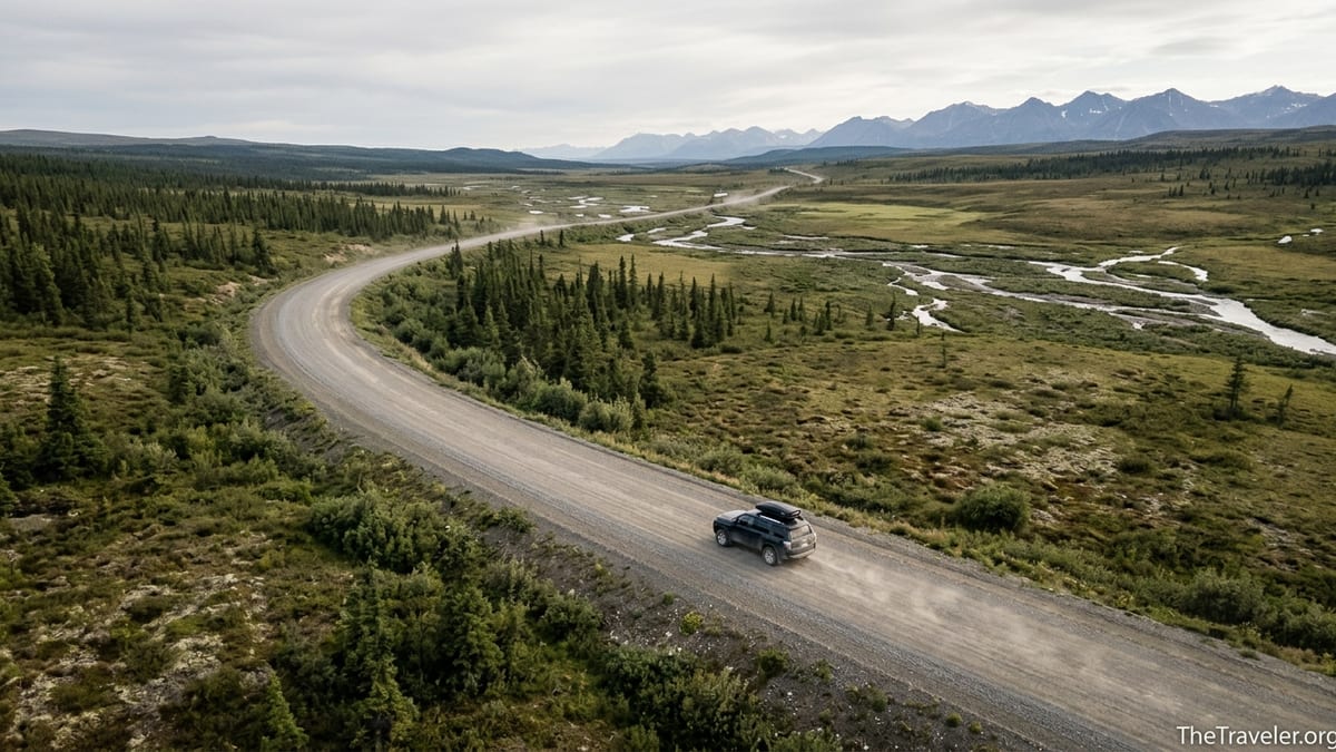
The Dempster Highway is a 740 kilometer gravel road that connects the Klondike Highway near Dawson City to Inuvik. It is built on permafrost affected terrain, so the surface is constantly shifting and being repaired. The Yukon government notes that permafrost affected roads can develop sudden dips, heaves and soft spots, and that gravel highways such as the Dempster demand slower speeds and increased following distances compared with paved roads. Drivers regularly encounter loose gravel, sharp stones, and sections treated with calcium chloride that become slick when wet.
Fuel and services are extremely limited along the Dempster. In the Yukon section, the primary service point is the Eagle Plains Hotel about halfway between Dawson City and the NWT border. Eagle Plains typically offers fuel, basic mechanical help, food and accommodation. North of the border, Fort McPherson and Tsiigehtchic provide fuel in the NWT portion, while Inuvik is the main northern hub. Recent traveler reports and regional tourism guides describe a common fuel pattern of filling in Dawson City, topping up at Eagle Plains, topping up again in Fort McPherson, and then filling completely in Inuvik before the side trip to Tuktoyaktuk.
Realistically, you should plan your vehicle range as if there were no backup options. That means carrying enough fuel to comfortably cover at least 500 kilometers between confirmed open stations, in case a pump is temporarily out of service. Many drivers carry a 20 liter jerry can, especially in shoulder season or when towing trailers. Fuel prices increase as you move north and onto gravel routes, so it is reasonable to expect to pay more per liter in Eagle Plains, Inuvik and Tuktoyaktuk than in Whitehorse or southern Canada. Rather than fixating on exact prices, it is more important to treat fuel as a safety resource and always fill when you can.
Safety planning on the Dempster is closer to expedition style than a typical highway trip. The Yukon government’s Dempster travel materials recommend carrying warm clothing even in summer, high energy food, extra water, a full size spare tire plus a second spare or repair kit, and communication devices such as a satellite messenger or personal locator beacon because cellular service is virtually nonexistent between Dawson and Inuvik. At Eagle Plains and some maintenance camps, emergency telephones or radio links to authorities are available, but you should not rely on quickly reaching them after a breakdown.
Driving to Tuktoyaktuk: The Inuvik to Arctic Ocean Stretch
From Inuvik, the final 140 kilometer road to Tuktoyaktuk is the Inuvik to Tuktoyaktuk Highway, sometimes called NWT Highway 10. Opened in 2017 as an all weather gravel road, it replaced the seasonal ice road that used to operate over the frozen Mackenzie Delta channels. The new road extends through tundra and low muskeg, with several small lakes and viewpoints where you can see pingos, the ice cored hills that are characteristic of the Tuktoyaktuk area.
Inuvik is your last major service center before the Arctic Ocean. The town has multiple fuel stations, grocery stores, hotels and restaurants. Many travelers choose to base themselves in Inuvik for two or three nights, driving to Tuktoyaktuk as a day trip. This allows you to leave most of your gear in a hotel and to return to a wider choice of dining and services in the evening. A typical day might involve leaving Inuvik by mid morning, taking around three hours to reach Tuktoyaktuk with photo stops, spending a few hours in the hamlet to walk the shoreline, join a local cultural tour or Arctic Ocean dipping experience, then driving back to Inuvik in the long northern evening light.
Tuktoyaktuk itself has a modest range of services relative to its size. The hamlet has fuel stations, small grocery shops, limited lodging options and local tour operators who offer boat excursions, cultural experiences and guided Arctic Ocean plunges. Many travelers describe buying snacks and fuel locally as one way to support the community economy. Accommodation options are more limited than in Inuvik, so if you hope to stay overnight, booking ahead in peak summer is important.
Surface conditions on the Inuvik to Tuktoyaktuk Highway can change quickly with weather. In dry spells the gravel can be dusty with loose marbles of stone that reduce traction, while rain turns certain sections into a slick, clay like surface. Large trucks servicing northern communities and projects also use this road, so you should expect and prepare for passing heavy vehicles at slow speed, pulling far to the right and reducing speed in order to minimize flying gravel.
Accommodation, Camping and Realistic Daily Distances
Accommodation options along this route range from city hotels in Whitehorse to wilderness campgrounds. In Whitehorse you will find familiar national hotel brands alongside local inns, plus commercial campgrounds and Yukon government campgrounds within a short drive of town. Dawson City offers historic hotels, modern motels, bed and breakfasts, and several campgrounds both in town and across the river. These hubs are good places to spend more than one night, both for sightseeing and to recover from long driving days.
On the Dempster Highway itself, the single major full service accommodation point is the Eagle Plains Hotel. This complex typically includes motel style rooms, a restaurant, bar, fuel pumps and limited repair services. It functions as a refuge in bad weather and as a social hub for truck drivers, highway crews and visitors. Campsites and basic territorial campgrounds are located at intervals along the highway, particularly near scenic areas such as Tombstone Territorial Park. Facilities are usually rustic, with pit toilets and no hookups, so self contained camping equipment is essential.
In the Northwest Territories, Inuvik offers several hotels, guesthouses and a commercial campground that often serves overlanders in vans and RVs. Tuktoyaktuk has a smaller, more variable set of accommodation options, sometimes including locally run guesthouses and informal camping areas near the shore where travelers park under midnight sun or northern lights depending on the season. Given the limited supply, it is wise to make cancellable bookings for at least your key nights in Eagle Plains and Inuvik before you travel north from Dawson.
In terms of distance planning, many experienced Dempster travelers recommend limiting daily drives to between 300 and 450 kilometers on the gravel sections. For example, Dawson City to Eagle Plains is around 370 kilometers and often takes five to seven hours once you account for slower speeds, photo stops and construction delays. Eagle Plains to Inuvik is a similar distance and time, depending on weather and ferry wait times. Trying to cover the entire Dempster in a single long day is possible only in ideal conditions and is not recommended for visitors unfamiliar with the road.
Emergency Preparedness and Seasonal Hazards
Emergency planning on the Yukon and Northwest Territories highways is not about expecting disaster but about recognizing that help can be many hours away. Even in midsummer there are long stretches of the Dempster where you may not see another vehicle for half an hour or more. If you have a mechanical problem or slide off the road in bad weather, you will need to keep yourself warm, visible and fed until help arrives. Practical measures include carrying enough warm layers for everyone in the car, even if you are traveling in July, as well as extra food and water sufficient for at least a full day beyond your planned supplies.
Tire issues are among the most common incidents on the Dempster. Sharp gravel and construction zones can cause punctures or sidewall damage, especially on heavily loaded vehicles or those running soft sidewall highway tires. Many travelers bring not only a full size spare but also a second spare or a quality plug kit and portable compressor, and they familiarize themselves with how to change a wheel before leaving pavement. A real world example often shared among drivers is that a single flat far from Eagle Plains can turn into an expensive tow if you do not have a workable spare, whereas those who carry proper gear can often get back on the road in under an hour.
Seasonal hazards vary. In early summer, lingering snow patches and saturated ground can make shoulders soft and muddy. In mid summer, wildfire smoke can reduce visibility and cause temporary closures, while sudden heavy rain can turn sections of calcium treated road into a slick, almost icy surface. In autumn, the first snows and freezing nights can catch late travelers by surprise, particularly on the higher passes of the Dempster. Across all seasons, wildlife such as caribou, moose and bears may appear unexpectedly on or near the roadway, so maintaining moderate speeds and scanning well ahead are crucial defensive driving habits.
Communication is another critical consideration. Outside of Whitehorse, Carmacks, Dawson City, Eagle Plains, Fort McPherson, Inuvik and Tuktoyaktuk, you should not count on mobile phone service. Satellite messengers that can send and receive short text based check ins have become common among independent travelers. While not mandatory, they provide peace of mind for both drivers and their families at home. Before departure, leave a simple written itinerary with a trusted contact, including planned overnight stops and approximate dates, and agree that you will check in when you have coverage or satellite messaging available.
Why Nunavut Requires a Different Arctic Travel Strategy
Looking at a map, it is tempting to assume that if you can drive to the Arctic Ocean at Tuktoyaktuk, similar road based trips might be possible into Nunavut. In reality, Nunavut is not connected to the rest of the Canadian highway network by all weather roads. The communities of Nunavut are primarily reached by air from hubs such as Yellowknife, Rankin Inlet or Iqaluit, and by seasonal sealift for cargo. There are some local and winter roads within regions, but nothing comparable to the continuous highway access you enjoy when driving from Whitehorse to Tuktoyaktuk.
This difference has important implications for trip planning. While a Yukon and Northwest Territories road trip is structured around vehicle choice, tire selection and fuel range, a visit to Nunavut is structured around flight schedules, local guides and outfitted trips. For example, a traveler who has driven the Dempster Highway might continue their Arctic exploration by flying from Yellowknife to Cambridge Bay or Iqaluit, then joining organized excursions for activities such as boat based wildlife viewing or cultural experiences in Inuit communities.
Costs and logistics also diverge. On the Dempster and Inuvik to Tuktoyaktuk routes, independent travelers can mitigate expenses by camping, cooking their own meals and sharing vehicle rentals. In Nunavut, accommodation and guided activities are typically more expensive due to the cost of bringing supplies and fuel in by air or barge, and independent camping without local knowledge can be unsafe because of polar bears and rapidly changing sea ice conditions. The skills you build planning a careful Yukon and NWT road journey transfer well to Nunavut in terms of respect for remoteness, but the tools you use will be aviation and local expertise rather than your own vehicle.
For many, the practical takeaway is that Nunavut is better approached as a separate trip or a distinct phase of a northern journey rather than as an extension of a Yukon road itinerary. Completing a Whitehorse to Tuktoyaktuk drive and then flying onward to a Nunavut community from an appropriate hub is a realistic way to link the two experiences, but they require very different strategies, budgets and timelines.
The Takeaway
A road trip from Whitehorse through Dawson City, up the Dempster Highway and on to Tuktoyaktuk is both accessible and demanding. The roads are public, the terrain is spectacular, and communities along the way welcome visitors, but the combination of long distances, limited services and variable gravel conditions means this is not a casual spur of the moment drive. Success depends on choosing a vehicle that is allowed and capable on the route, planning conservative daily distances, and treating fuel, tires and communication as core safety concerns rather than afterthoughts.
In return, the rewards are significant. You will cross entire climatic zones in a single journey, from spruce forest near Whitehorse to open tundra near the Arctic Ocean. You will see historic Dawson City, the dramatic ridges of Tombstone Territorial Park, the rolling plateau around Eagle Plains, the braided channels of the Mackenzie Delta and the pingos near Tuktoyaktuk. These are landscapes and communities that most visitors only ever see from an aircraft window.
Understanding that Nunavut sits outside the road network you have used to reach Tuktoyaktuk is equally important. The fact that you can drive to the Arctic Ocean in the Northwest Territories should not obscure the reality that much of the Canadian Arctic remains fly in territory, with its own travel logic and requirements. If you treat each region on its own terms, with realistic expectations and careful preparation, northern Canada offers some of the most memorable and responsible adventure travel opportunities in the world.
FAQ
Q1. What is the best time of year to drive from Whitehorse to Tuktoyaktuk?
Most independent travelers aim for late June to early September, when the Dempster Highway is usually snow free, river ferries in the Mackenzie Delta are operating, and daylight is long. Outside this window, snow, ice and limited services make the trip more complex and suitable mainly for experienced winter drivers.
Q2. Do I need a 4x4 to drive the Dempster Highway and the road to Tuktoyaktuk?
A true 4x4 is helpful but not absolutely mandatory in mid summer. What matters more is good ground clearance, durable tires and a rental agreement that explicitly allows travel on the Dempster. Many travelers use all wheel drive SUVs, but they drive slowly and carry proper spares.
Q3. Are there rental companies in Whitehorse that allow driving on the Dempster Highway?
Some regional and specialist outfits in Whitehorse and Dawson City do allow their vehicles on the Dempster under specific conditions, such as using an SUV class vehicle and accepting higher deductibles or gravel road surcharges. Large national brands often prohibit the Dempster entirely, so you must confirm permissions in writing before booking.
Q4. How often will I find fuel between Dawson City and Tuktoyaktuk?
Fuel is available in Dawson City, at Eagle Plains, in Fort McPherson, in Inuvik and in Tuktoyaktuk, but distances between these points are large and opening hours can vary. It is wise to treat your range as if you might go 400 to 500 kilometers between reliable fuel stops and to carry an extra jerry can as backup.
Q5. Can I rely on mobile phone coverage along the Dempster Highway?
No. Outside communities such as Dawson City, Eagle Plains, Fort McPherson, Inuvik and Tuktoyaktuk, mobile coverage is very limited or nonexistent. Many travelers bring a satellite messenger or personal locator beacon for emergency communication and leave a detailed itinerary with someone at home.
Q6. What kind of accommodation is available on the Dempster Highway?
The main full service option is the Eagle Plains Hotel, which offers rooms, a restaurant, fuel and basic mechanical help. In addition, there are government campgrounds and informal camping areas along the highway, especially near Tombstone Territorial Park, but facilities are generally basic and require self sufficient camping gear.
Q7. Is the road from Inuvik to Tuktoyaktuk paved?
No. The Inuvik to Tuktoyaktuk Highway is an all weather gravel road. In dry periods it can be dusty and loose, while rain can make sections slick. Drivers should be prepared for changing surface conditions and for sharing the road with heavy trucks.
Q8. How many days should I plan for a round trip from Whitehorse to Tuktoyaktuk?
A realistic minimum for a comfortable round trip is about 10 to 14 days. This allows time for Whitehorse to Dawson City, two or three days each way on the Dempster, at least one full day for the Inuvik to Tuktoyaktuk return, and extra time for weather delays and sightseeing.
Q9. Why can I not just drive into Nunavut the way I drive to Tuktoyaktuk?
Nunavut has no all weather highway link to the rest of Canada. Its communities are reached primarily by air and seasonal sea lift, with only local or winter roads within regions. Visiting Nunavut therefore requires a different strategy based on flights and local guides rather than a personal vehicle.
Q10. Do I need special permits to drive the Dempster Highway and the road to Tuktoyaktuk?
There is no general public road permit required for private vehicles, but you must comply with local laws, observe any seasonal advisories and, if using a rental, meet the rental company’s conditions for travel on these highways. Checking with visitor centers and government road reports before departure is strongly recommended.