

The first glimpse of the mountains came as a pale blue smudge on the horizon, somewhere past the Calgary city limits sign on Highway 1. It was just after 7 a.m., a cool July morning with a high thin cloud layer that promised mild temperatures and soft light, and I was heading not for Banff, where most of the traffic was pointed, but for the quieter valleys of Kananaskis Country. My goal for the day was Rawson Lake, a subalpine bowl above Upper Kananaskis Lake, and an honest test of whether this lesser-known region could truly offer a better day out than the famous streets and trails of Banff.
Leaving Calgary Behind For Kananaskis
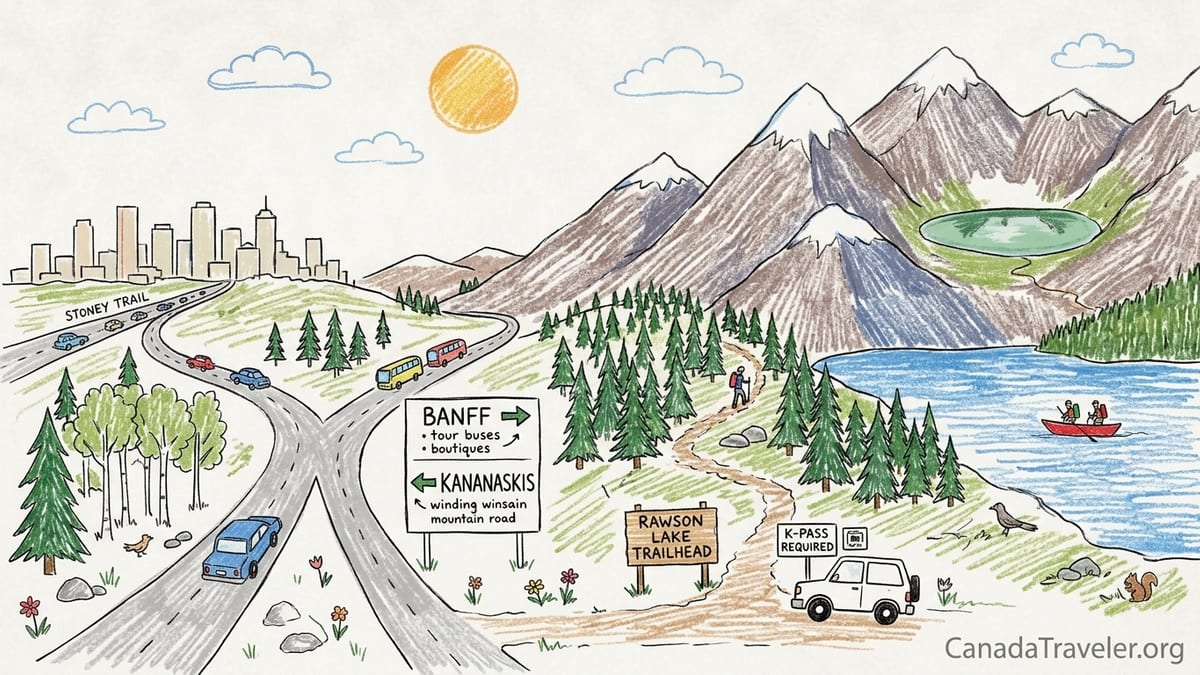
I left northwest Calgary just as the morning commuters started to thicken on Stoney Trail. Instead of following the familiar flow west toward Banff, I cut south on Highway 22 and then west again to meet Highway 40, the Kananaskis Trail. That decision, made at a nondescript interchange, was the real fork in the road: Banff or Kananaskis, boutiques and tour buses or quiet pullouts and trailhead pit toilets.
By the time I turned onto Highway 40, the city had fallen away completely. The road narrowed and began to rise gently through foothills patched with spruce and aspen. Peaks began to appear one by one, not the postcard skyline you see from Banff Avenue, but close and textured mountains leaning over the roadside. Cell service dropped out in patches and the radio fell to static, replaced by the thrum of tires on pavement and the rush of the Kananaskis River.
I passed the seasonal gate that closes the road south over Highwood Pass each winter. Here the reality of planning a Kananaskis trip becomes obvious. Each year, the high elevation section of Highway 40 that crosses Highwood Pass is closed to vehicles from December 1 until mid June, normally June 15, to protect wildlife and reduce collisions. In my case, it was mid summer and the gate stood open, but seeing it made me conscious that access in shoulder seasons is far less predictable here than in Banff, where the Trans Canada Highway remains open year round.
From the junction with Kananaskis Lakes Trail, it took about twenty more minutes to reach the Upper Kananaskis Lake Day Use Area, the trailhead for Rawson Lake. The final approach wrapped around the lake shore, views opening to ridgelines behind the water. The parking lot was already busy with trucks and compact cars by 8:45 a.m., but it felt more like a local crowd than the tour buses that dominate Banff’s main lots on a summer Saturday.
Trailhead, Conservation Pass And First Steps
Before I even laced my boots, Kananaskis reminded me that hiking here involves a bit more paperwork than simply showing up. To park at the Upper Kananaskis Lake Day Use Area, my vehicle needed a valid Kananaskis Conservation Pass. At the time of my visit, the pass for a personal vehicle cost 15 Canadian dollars per day or 90 dollars for an annual pass covering up to two vehicles registered to the same household. The critical detail is that the pass is required when you park at designated provincial park and public land sites within the Kananaskis pass area, not merely for driving through on Highway 40.
I had bought my pass online the night before, registering my license plate through the provincial system, but there are also in-person options at places like the Kananaskis Visitor Information Centre and the Canmore Nordic Centre. The process was straightforward: create an account, choose daily or annual, enter plate details, and keep the confirmation email. Conservation officers in the parking lot were clearly checking plates with tablets that scan numbers; there are no paper hang tags for most vehicles, so having the plate correct is essential.
There are exemptions and supports, but they are specific. Residents who meet low income criteria can apply for a 30-day exemption pass, and certain provincial volunteers and Indigenous users with rights in the area may qualify for exemptions as well. However, neither regular Alberta residents nor out-of-province visitors are automatically exempt. Unlike the limited-time Canada Strong Pass that made entry to Banff and other national parks free in summer 2026, the Kananaskis Conservation Pass remains in effect and is checked routinely. For our car of two adults, the 15 dollar daily pass became part of the cost equation for choosing Kananaskis over Banff.
The Rawson Lake trailhead sits at the south end of the Upper Kananaskis Lake Day Use parking. A wooden sign points to the Upper Kananaskis Lake trail, with Rawson Lake branching off after a short lakeside walk. The posted details listed a round trip distance of roughly 7 to 8.5 kilometres to the end of the maintained trail at the lake, with about 300 metres of elevation gain. Several regional guides describe the out-and-back as an 8.7 kilometre hike with approximately 630 metres of elevation if you continue further, but my plan was to hike from the parking lot up to the lakeshore and modestly along its edge, not to push on to the higher Sarrail Ridge.
Into The Forest: Climbing Toward Rawson Lake
The first kilometre was deceptively gentle, following the wide, rooty shoreline of Upper Kananaskis Lake. I walked past families in sneakers heading for lakeside picnic spots, the trail broad enough to chat and step aside easily. Views across the water to Mount Indefatigable were partially veiled by morning haze, but reflections still formed on the lake’s surface. The air smelled of damp earth and spruce needles from rains earlier that week.
After crossing a sturdy wooden bridge over the creek, the Rawson Lake trail split off from the lakeshore and began to climb in earnest. The tread narrowed to a classic singletrack worn into dark soil, zigzagging up the hillside through dense subalpine forest. This section, about two kilometres long, delivered most of the elevation gain in a series of switchbacks. My GPS watch later recorded roughly 400 vertical metres from the lake shore to the bench above Rawson Lake, a figure that matched the "moderate" ratings I had read but still felt surprisingly sustained underfoot.
Trail conditions were typical for Kananaskis in mid-summer. Exposed tree roots, a few short muddy stretches where seeps crossed the path, and the odd loose rock demanded attention. Hiking shoes or light boots were clearly preferable to casual trainers, especially on the descent. The grade was steady rather than punishing, but the forest offered few views, which made it easy to underestimate progress. Every so often the trees would thin just enough to give a quick glimpse back over Upper Kananaskis Lake, a reminder of how quickly the trail was gaining height.
As the trail climbed, the crowds thinned. Rawson Lake is a popular outing by Kananaskis standards, especially on weekends, but the number of people was still significantly lower than what I am used to on comparable-length hikes near Banff townsite, such as Tunnel Mountain or the lower slopes of Sulphur Mountain. I was rarely alone, yet I never fell into the stop-start shuffle that often happens on busy Banff trails where groups stack up at every viewpoint.
Reaching The Lake: Subalpine Calm Instead Of Crowded Boardwalks
The first sign that I was approaching Rawson Lake was the smell of cold water and a faint brightness ahead through the trees. The trail crested a final rise, and suddenly the forest gave way to an open bowl. Rawson Lake stretched out in a long, greenish ellipse beneath the cliffs of Sarrail Ridge, its surface rippled by a light breeze. Snowfields clung to the north-facing gullies well into July, streaking the grey rock with white.
The maintained trail skirted the near shore across compact dirt and roots, with intermittent wooden steps built into wetter spots. A sign near the official trail end asked hikers not to continue into more fragile shoreline areas to protect the lakeside vegetation and minimize erosion. I followed the path to a natural bench above the lake, where a cluster of fallen logs made a convenient lunch spot. Unlike the boardwalks and fences that often define prime viewpoints in Banff, this felt refreshingly unconstructed yet still clearly managed.
From this angle, the subalpine character of the basin came into focus. Bands of spruce and fir gave way to lighter green patches of low shrubs and dwarf heather near the water. There were wildflowers, though not the riotous carpets sometimes seen in open meadows. Instead, delicate paintbrush and asters poked between stones along the trail margin. The sense was of a living yet fragile alpine environment, better appreciated in quiet moments than in a rush for social media photos.
I lingered for almost an hour, listening to the muffled conversations of other hikers drifting across the water. It never felt crowded. There were moments when I could hear only wind and the distant crack of rockfall high on the ridge. That contrasted sharply with my mental picture of places like Lake Louise or Moraine Lake near Banff, where early morning shuttle buses, full parking lots, and managed queues for photo spots have become the norm on peak days. Rawson Lake was not empty, but the density of people and the absence of commercial noise made the experience feel more intimate.
Wildlife, Safety And Limited Infrastructure
On the hike itself, wildlife encounters were limited to songbirds and a red squirrel scolding hikers near the shoreline. That was fine by me. The trailhead bulletin board carried several bear warnings, and recent reports from along Highway 40 mentioned grizzly activity near Highwood Pass and occasional temporary closures after bluff charges. The ecological richness that makes Kananaskis appealing also demands a higher level of awareness than many visitors expect if they are used to the more open, heavily trafficked areas around Banff townsite.
Like most other hikers, I carried bear spray on my pack’s hip belt and hiked in a small group, talking as we walked through thicker forest sections. Standard guidance in Kananaskis recommends keeping at least 30 metres from most wildlife and far greater distances from bears, never approaching for photos or feeding. Rawson Lake’s trail feels managed and well used, but the surrounding valleys are genuinely wild, and closures for wildlife movement or incidents are not theoretical. Sections of Highway 40 have seen seasonal and incident-related restrictions, whether for the winter wildlife closure over Highwood Pass or occasional mudslides in recent years.
Infrastructure on this hike was minimal: pit toilets at the parking lot, basic signage at junctions, and one bridge near the lakeshore. There were no garbage bins beyond the day use area and certainly no coffee kiosks or souvenir shops. Cell service dropped out shortly after leaving the highway and did not return until we were driving back toward Kananaskis Village. This is typical for much of Kananaskis Country; anyone used to relying on mobile maps and messaging in Banff’s main corridors will need to download offline maps and share a day plan before leaving town.
The lack of amenities affects timing as well. There is no public transit to the Upper Kananaskis Lake trailhead, so every visitor must either drive or join a private tour or shuttle, which are less common than in Banff. Parking pressure is real on warm weekends, and overflow parking can mean a longer walk to the trailhead. When we returned to the lot around 2 p.m., rangers were monitoring roadside parking and checking for valid Conservation Passes. Illegally parked or unpermitted vehicles risk tickets, a cost that can quickly erase any savings from choosing Kananaskis over a national park visit.
Costs And Crowds: Kananaskis Versus A Day In Banff
By mid afternoon I had a clearer sense of how my Rawson Lake day stacked up against a typical summer day in Banff. On the Kananaskis side, our hard costs were straightforward. The Kananaskis Conservation Pass was 15 dollars for the vehicle for the day. There were no other mandatory fees, since we brought our own food and water and skipped any post-hike restaurant stops. Gas from Calgary to Upper Kananaskis Lake and back added its own line item, but that cost would apply to a Banff trip as well.
In Banff National Park, driving from Calgary for a comparable day would involve a Parks Canada entry fee, charged per person or per vehicle group. A family or group day pass is designed for up to seven people in one car and typically costs a bit more than the Kananaskis Conservation Pass, although exact national park rates vary by year and by pass type. In summer 2026, many visitors benefited from the Canada Strong Pass, which temporarily made national park admission free for several weeks and discounted camping, but that program had a fixed end date in September. Outside such special offers, Banff remains a place where admission fees and commercial temptations can quickly add up.
Then there are the optional yet common expenses. In Banff, it is easy to turn a hike into a full-day spend with cafes, paid parking in town, or shuttle fares to popular trailheads like Lake Louise and Moraine Lake, where private vehicles are now heavily restricted and shuttles or tours are mandatory for many time slots. By comparison, Kananaskis has far fewer ways to spend money once you arrive. There are a few lodges, a gas station, and some roadside eateries in the broader region, but no dense strip of shops like Banff Avenue. That lack of commercial density is precisely what many hikers are seeking.
Crowds presented an even sharper contrast. Banff’s busiest spots in peak season often feel more like small cities than mountain towns, with tour buses, day trippers, and international travellers all sharing limited space. Trails close to town can be congested by late morning, and parking lots regularly fill with vehicles circling. In Kananaskis, especially around Upper Kananaskis Lake, the parking lot did fill, but the density on the trail remained much lower. Conversation with other hikers revealed a more regional mix: Calgarians on day trips, Albertans from nearby towns, and a smaller number of out-of-province visitors who had done enough research to venture beyond Banff.
What Felt Different On The Ground
By the time we drove back toward Calgary, late light slanting across the Kananaskis Valley, I understood more clearly why Rawson Lake and Kananaskis in general felt different from Banff, even if the peaks and forests share a similar geology. The most obvious difference was the absence of continuous commercial infrastructure. After leaving the Trans Canada Highway and passing the last service station near Kananaskis Village, there were long stretches with no services and only small day use areas. Trailheads were simple: gravel lots, information boards, pit toilets.
This simplicity translated into a stronger sense of being in a working mountain landscape rather than a tourist corridor. Highway 40 doubles as both an access road for recreation and a route through an important wildlife habitat. The seasonal closure over Highwood Pass, which each year closes to vehicles from December 1 until mid June, exists in large part for the benefit of animals rather than visitors. In Banff, similar ecological considerations are present, but the sheer volume of infrastructure and visitors can make them feel abstract. In Kananaskis, they are built into the rhythm of the place.
The scenery also had a distinct character. Rawson Lake’s intimate basin, with cliffs rising almost directly from the shore, contrasted with the broader, more grandiose vistas of the Banff area lakes. From the lakeshore, there were no hotels in sight, no distant gondolas or paved lakeside promenades. The views looked much like old photographs from before the Rockies became an international destination. That sense of being in a place that still functions primarily on mountain time, where snow, wildlife, and road washouts can dictate access, was one of the most appealing aspects of the day.
If there was a trade-off, it lay in the requirement for more self-reliance. In Kananaskis, with weak cell service, fewer staffed facilities, and more variable access, planning becomes part of the experience. You must check for trail advisories, road closures, and bear warnings in advance, purchase and register the Conservation Pass, and ensure you have everything from extra layers to a full gas tank before leaving town. Travelers who find comfort in Banff’s plentiful cafes, hotels, and visitor centres may see this as a drawback, but for those seeking a quieter day in the mountains, it is often part of the allure.
The Takeaway
My day hiking to Rawson Lake convinced me that Kananaskis Country can offer a richer, calmer mountain experience than a typical day in busy Banff, provided you approach it with realistic expectations and a bit of extra preparation. The Rawson Lake trail delivered an accessible yet satisfying hike of roughly 8 kilometres return, with 300 to 400 metres of elevation gain, on a well-maintained path that still felt rooted in wild surroundings. It matched the guidebook description in difficulty and scenery, yet exceeded my expectations in terms of tranquillity at the destination.
Practically, the Kananaskis Conservation Pass is an unavoidable part of the equation. At 15 dollars per day for a personal vehicle or 90 dollars annually for households that will visit repeatedly, it adds cost but also helps sustain washrooms, trail maintenance, and conservation efforts in a heavily used yet lightly serviced area. Understanding that the pass applies when you park at designated sites, not just when you drive through, is crucial. So is checking whether you qualify for any exemptions, such as low income programs, before assuming you must pay full price every visit.
Stacked against a Banff day, Kananaskis felt less polished and more remote, even though the drive time from Calgary was similar. There were no main streets to wander, no hot springs to soak in after the hike, and no string of restaurants waiting for diners. But there was also no line for coffee at sunrise, no hunt for paid parking near a crowded trailhead, and no need to book shuttle buses weeks in advance. For me, that trade-off tilted decisively in Kananaskis’s favour.
Kananaskis will not suit every traveler. Visitors who want an easy blend of mountain scenery, dining, shopping, and structured tours will still be happier basing themselves in Banff, using its extensive infrastructure and transportation systems. But hikers and photographers who value quieter trailheads, a feeling of genuine remoteness, and a closer connection to the natural rhythms of the Rockies will likely find Kananaskis worth the additional planning, the Conservation Pass, and the uncertainty that comes with wild roads and weather. On balance, my Rawson Lake day felt less like consuming a destination and more like briefly inhabiting a living mountain valley, and that is why, given the choice, I would steer south on Highway 40 again.
FAQ
Q1. Do I need a Kananaskis Conservation Pass to hike to Rawson Lake?
Yes. If you park at the Upper Kananaskis Lake Day Use Area trailhead, your vehicle must have a valid Kananaskis Conservation Pass, either a 15 dollar daily pass or a 90 dollar annual pass registered to your license plate.
Q2. How long is the Rawson Lake hike and how hard is it?
The hike from the Upper Kananaskis Lake parking lot to Rawson Lake and back is roughly 7 to 8.5 kilometres return, with around 300 to 400 metres of elevation gain, on a well-defined forest trail. Most reasonably fit hikers consider it a moderate outing that typically takes 3 to 4 hours, plus extra time spent at the lake.
Q3. Where exactly is the Rawson Lake trailhead?
The trail starts at the south end of the Upper Kananaskis Lake Day Use Area in Peter Lougheed Provincial Park. From the main lot, you follow the lakeshore trail until you see signed junctions directing you uphill to Rawson Lake.
Q4. When is Highway 40 over Highwood Pass closed?
Each year, the high elevation section of Highway 40 that crosses Highwood Pass closes to vehicles from December 1 until mid June, usually reopening around June 15, to protect wildlife and reduce collisions. This affects access to some Kananaskis trailheads and should be checked when planning shoulder-season trips.
Q5. Is Kananaskis really less crowded than Banff?
Kananaskis is quieter overall than the busiest parts of Banff, but popular hikes like Rawson Lake, Grassi Lakes, and Ptarmigan Cirque can still be busy on summer weekends. You should not expect solitude but you are less likely to encounter the shoulder-to-shoulder crowds that gather at Banff’s most famous viewpoints.
Q6. Are there any exemptions or free days for the Kananaskis Conservation Pass?
Some low income Albertans, eligible volunteers, and certain Indigenous users can apply for exemptions or no cost 30 day passes through provincial programs, but there are no broad, scheduled free days equivalent to national park fee free days. Most visitors should plan on purchasing a daily or annual pass.
Q7. How does the cost of a Kananaskis day compare with Banff?
In Kananaskis, a typical self guided hiking day by car often involves the 15 dollar Conservation Pass plus fuel and food you bring. In Banff, visitors usually pay a national park entry fee per group or individual, and may add shuttle fares, paid parking in town, restaurant meals, and other commercial expenses, so total out of pocket costs can be higher.
Q8. What are the main safety considerations when hiking in Kananaskis?
Key considerations include traveling in bear country, carrying and knowing how to use bear spray, giving wildlife plenty of space, monitoring changing weather at higher elevations, and recognizing that cell service is limited. Checking current trail reports and any wildlife or closure notices before departure is essential.
Q9. Is Rawson Lake suitable for beginners or families?
Rawson Lake is accessible for strong beginners and families with older children who are comfortable with sustained uphill walking and uneven forest trail conditions. It is not stroller friendly, and younger children or those new to hiking may find the elevation gain challenging, especially on the descent.
Q10. Who should choose Kananaskis over Banff for a day hike?
Travelers who prioritize quieter trails, a more natural atmosphere, and do not mind planning ahead for passes, road closures, and limited services are good candidates for Kananaskis. Those seeking a broader mix of dining, shopping, transit options, and structured tours may be better served by basing their day in Banff.